


- On sale!
- -25%

 By buying this product you can collect up to
28
points.
Your cart will total 28
points that can be converted into a voucher of
€4.20.
By buying this product you can collect up to
28
points.
Your cart will total 28
points that can be converted into a voucher of
€4.20.
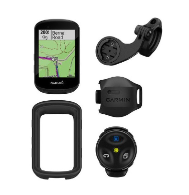
Brand- Garmin
Edge 800 + Heart Rate Monitor + Speed / Cadence Sensor + microSD TrekMap Italia V3 Pro
Edge 800 + Heart Rate Monitor + Speed / Cadence Sensor + microSD TrekMap Italia V3 Pro
Packaging:
Edge 800
Premium heart rate monitor
Speed/cadence sensor
MicroSD data card preloaded with TrekMap Italia V3 topographic cartography Pro
Bicycle Bracket
AC Charger
USB cable
Quick Start Manual
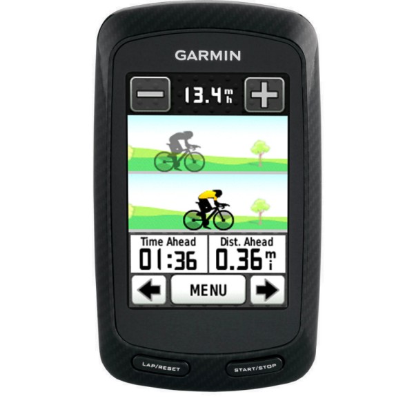
Make the most of every ride with the Edge® 800 - the first touchscreen Bike GPS. Ideal for competitive, amateur and touring, road and mountain biking, it has a built-in worldwide basemap (microSD slot) and tracks distance traveled, speed and location in real time. Use it with the bundled or optional heart rate monitor, speed/cadence sensor or an ANT+ compatible power meter for a detailed analysis of your run.
Everything at your fingertips
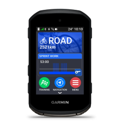
The touchscreen display of the Edge 800 is resistant to the elements and shocks, and very sensitive to respond quickly to the touch of your finger, even with gloves, to change training screens or to zoom the map with a simple "tap". It is bright, in color, and is readable in daylight and in any lighting conditions. The Edge 800 is waterproof up to IPX7.
The aerodynamic Edge 800 model features a carbon fiber design with blue or white inserts and is fixed to the stem or handlebar bend itself via the supplied bracket.
You always know where you are and where to go
Edge 800 is compatible with our microSD™ cards that can also be purchased directly from our website, and can also guide you along routes recorded and shared by other cyclists. Explore our Garmin Connect site and choose from millions of routes uploaded by other Garmin users. All the data is stored on the Edge 800 as runs, and you can follow them via navigation commands or, for a bit of competition, try to beat previously set goals. You can also use BaseCamp™' Garmin software or other apps (such as Bird's Eye® - for a fee) for free to create a route, analyze data such as elevation changes, and upload it to the Edge.
Edge 800 records your every move with a high sensitivity GPS receiver. The receiver features HotFix® satellite acquisition technology to calculate position faster and advanced First Beat™ calorie consumption calculation.
Data... in all the ways you want
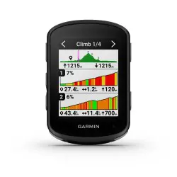
Edge 800 tracks your ride and provides real-time data, and lets you customize the view so you can see only the information you want. The barometric altimeter also provides, with extreme precision, the data of ascent and descent and temperature changes, and not to forget, the average ascent rate (VAM).
For cyclists looking for even higher performance, you can pair Edge 800 with a third-party power meter (ANT+™) to show you how much power you produce in watts during your ride. This shows how hard you are working, regardless of your running conditions, so that you can train smarter. The Edge 800 can also be paired with compatible third-party ANT+ ™ body fat index scales.
Training tools
Need motivation to push your performance to the limit? Try competing against the Virtual Partner®, a digital representation of your speed goal against your own speed in real time. Among other tools, you can take advantage of the detailed training planning systems, Auto Pause®, Auto Lap® and Corse, which allows you to compare subsequent outings on the same route.
Running analysis
After your run, you can review, replay and share your performance. Simply upload your data to Garmin Connect, our free website for data analysis and sharing. To upload data from your PC or Mac, you can use the included USB cable. On the Garmin Connect website, you can see your route on a map, view a summary of your run, create goals, share data with others, etc.
Appearance and performance:
Unit Dimensions, W x H x D: 2" x 3.7" x 1" (5.1 x 9.3 x 2.5 cm)
Display Size, W x H: 1.4" x 2.2" (3.8 x 5.6 cm); 2.6" (6.6 cm) diagonal
Screen resolution, W x H: 160 x 240 pixels
Touchscreen: Yes
Weight: 3.5 oz (98 g)
Battery: Rechargeable lithium-ion
Battery life: 15 hours, typical use
Water Resistance: Yes (IPX7)
GPS-enabled: Yes
High sensitivity receiver: Yes
Maps and Memory:
Base map: yes
Possibility of adding maps: yes
Data card acceptance: microSD™ card (this version includes Trekmap UK V3)
Lap history: 1000 laps
Waypoints/My Locations/Locations: 200
Paths: Based on available memory
Features:
Heart rate monitor: yes (some versions)
- Pedaling speed/cadence sensor: yes (some versions)
Shoe accessory: no
Automatic synchronization (automatically transfers data to your computer): No
Compatible with Garmin Connect™ (online community where data can be analyzed, classified and shared): yes
Compatible with Garmin Training Center® software: yes
Virtual Partner® (allows you to train with virtual people): yes
Virtual racer™ (compete against other activities): no
Routes (allows you to compete with previous activities): Yes
Auto Pause® (stops and wakes the timer based on speed): Yes
Auto Lap® (automatically starts a new giro): Yes
Auto-scroll (scrolls through data pages during workouts): Yes
Sport (allows you to change the sport type at the touch of a button): no
Advanced workouts (allows you to create personalized workouts, targeted to the goal to be achieved): yes
Simple workouts (goals for exercise time, distance and calories): Yes
Pitch alarm (triggers an alarm when the preset pitch is altered): Yes
Time/distance alarm (triggers an alarm when target is reached): yes
Vibration: (allows you to choose between alert tones and/or vibration): No
Training interval (allows you to set training and rest intervals): Yes
- Heart rate-based calorie calculation: Yes
Training effect (measures impact of an activity on your aerobic fitness): no
Custom screen(s): Yes
Barometric altimeter: Yes
Drive-to-drive transfer (allows you to share data wirelessly with similar drives): No
Power meter compatible (allows power data to be displayed via compatible third-party ANT+ ™ enabled power meters): Yes (data logging approx. 1 per second)
Temperature (displays and records temperature while you ride): Yes
Sports watch: no
Additional Features: Operating Temperature: -20°C to +60°C
Topographic map Garmin Trekmap Italia V3 PRO
OVER 100,000 KM OF PRELOADED TRAILS
TrekMap Italia v3 PRO is the topographic cartography of Italy that covers the entire national territory and integrates the hiking networks in some selected areas. The hiking coverage concerns in particular the entire Alpine arc and the Apennines up to Lazio, as well as the paths of the Natural Park of the Simbruini Mountains and those of Aspromonte, in Calabria.
OVER 200 THEMATIC HIKING AND CYCLING ROUTES
In addition to the hiking network, thematic itineraries are preloaded for a total of about 12,000 kilometers including, for example, the Via Francigena di San Francesco, several hiking High Routes, the Bolzano-Ferrara cycle path and, for mountain biking, numerous short tours as well as famous classics such as the Via dell'Assietta or the ascent to the Colle del Sommelier.
MADE IN COLLABORATION WITH THE BEST OUTDOOR PROFESSIONALS
All the data included in TrekMap Italia v3 PRO come exclusively from highly authoritative suppliers, to offer you a cartographic product full of interesting, accurate and precise content, as well as a "cartographic base" on which to plan and relive your excursions.
25% MORE COVERAGE THAN THE PREVIOUS VERSION
The entire hiking network has been updated and increased by about 25% compared to the previous version, now covering over 113,000 kilometers (including paths, cycle paths and mountain bikes), while the road network has been completely updated, even inserting house numbers that allow navigation even at individual addresses.
CLEARER THAN EVER WITH NEW COLORS AND NATIONAL PARKS
The color scheme of the cartography has been improved, making it more readable and pleasant, and the areas of the National and Regional Natural Parks have been included in superimposition and not only (as in the previous version) as borders.
BEING ON MICRO SD CARD it is EASIER TO USE
No CDs or DVDs, no unlock codes, no installation needed: the cartography is already ready on the preloaded memory card, just insert it into the GPS and go. And to use it on your computer, no problem. The free Garmin BaseCamp software can read and display maps on your computer screen directly from your memory card... even if inserted in the GPS!


Edge 800 + Heart Rate Monitor + Speed / Cadence Sensor + microSD TrekMap Italia V3 Pro